First let me begin by saying I am in no way affiliated with QGIS...Now that said...
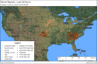
I've been playing around with QGIS recently. It seem's to do a great job with GIS related tools and thought I would share a weather map I created with several different shapefiles that are found online.
Here is one I did tonight of storm reports in the USA in the last 24 hours from the time I created it.
 QGIS - A Free and Open Source Geographic Information System
Note: Click to open thumb, then right click and open image in a new tab and zoom for the full detail of it.
As for the program website you can find it @
https://www.qgis.org/en/site/The data for that one came from IEM @
http://mesonet.agron.iastate.edu/GIS/.
Anyone else heard of/used it and have any thoughts of their own to share?
