You mentioned those other signal sources, beyond GPS: A-GPS, Glonass, TTFF, BDS - so these are all GPSsignals, just from non-GPS satellites, or in other words, technically, they are all the same, but they are named differently since the organizations behind them are different?-ital2
GPS - generically refers to all Global Positioning Systems or just the USA implementation which was the first in orbit (1978).
GLONASS (Globalnaya Navigazionnaya Sputnikovaya Sistema) - Russian implementation of GPS
BDS (BeiDou Navigation Satellite System) - Chinese implementation of GPS
Galileo (Global Navigation Satellite System) - EU implementation of GPS
There are probably others by now.
The main reason behind why there are so many different implementations is to prevent lockout by a country if there was only a single system.
TTFF isn't a signal, it's an acronym for Time To First Fix - the time taken to get a position fix after switching on the device.
A-GPS is Assisted GPS, not a signal either but rather a function that allows for faster TTFF by downloading of GPS Almanac data from the internet (rather than the GPS satellites) and providing an approximate position using trilateration from mobile phone signals. GPS devices will work without A-GPS.
BTW, there is actually two types of data transmitted by GPS satellites:
- Almanac - which is orbital data about the whole system, this data is good for a month or more.
- Ephemeris - which is accurate course/clock data concerning that particular satellite, only good for about 30 minutes. (If a receiver has been turned off longer than that it needs to obtain this data again from the satellite.)
And you spoke of 3m accuracy, your device getting signals from 18 out of 27 satellites. That seems perfect. So I suppose it depends on the device if it is able to get those signals other than GPS, too, and perhaps it's also a question of the map software then if it, or some intermediary software proper to the device itself, can aggregate all this info.
Accuracy is provided by the GPS receiver hardware, nothing to do with the software or maps. The GPS receiver reports it's position, the software interprets that and displays it on a map - if the software/map is calibrated wrong, then it will show your position as somewhere you aren't.
You now also mention D-GPS / Differential-GPS, I suppose high-end navigation devices can treat them.
Usually only required by people who need that kind of accuracy, eg. surveyors.
There are also GPS satellites in orbit that provide a measure of accuracy improvement,
WAASw (Wide Area Augmentation System) and EGNOS, (although I've just seen there are others now). As usual, the GPS receiver has to be capable of utilising data from these sources.
But to answer your question, I thought the satellites also sent their position and an identification code,
They do.
and that the receiver also receives lists of which satellite is where when or does what orbit and such,
It does.
But without some means of identifying which direction you're facing, how is the device supposed to indicate your bearing?
Hence the need for an internal compass.
that's why I so heavily rely upon maps and compasses,
I still use paper maps, I've never needed a compass. All my maps are topographic, I can work out my position from what terrain I'm on, heading towards, or have driven through.
You sometimes speak of your receiver, which is obviously very, very good, and then you speak of your smartphones or tablets. What is your current receiver, or do you mean the one built into your current smartphone?
My GPS receiver is a 14 year old
Garmin Geko 201, it's not very very good, it was cheap but it does the job. I don't I've seen better than 5m accuracy on it, (also called HDOP, Horizontal Dilution Of Precision). Before that I had a
Garmin GPS38 which was even slower and less accurate.
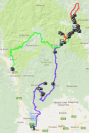
My use of GPS, (whether dedicated or phone/tablet), is almost 100% for a track log, not as a navigation aid - I'm more interested in where I've been rather than where I'm going. I have very little interest in following a pre-programmed track.
eg.

2m is awesomely impressive! Perhaps we could deduct that some makers use better gps receivers in their smartphones/tablets than others. This interests me a lot, since when in some town I do a 90-degree turn, it would be nice to have the map rotating after 15, 20 m instead of 150, 200 m only!
I have had my phone report 1m accuracy but that's rather rare so I don't bother quoting that figure, plus that degree of accuracy in not something you should rely on in a device that costs less than US$130.


 Recent Posts

